
The Susquehanna River has drawn people to its banks for thousands of years. Many of our Susquehanna Greenway River Towns were built where former Native American villages once maintained extensive agricultural fields, towns, and roads along the easily navigable shores of the Susquehanna River. Acknowledging the importance of Indigenous people in Pennsylvania’s past, present, and future is key to understanding and respecting the Susquehanna Greenway that we explore today.
Many familiar names throughout the Susquehanna Greenway have their roots in Native languages. In the Northern regions of the Susquehanna River, most Indigenous people spoke variations of the Haudenosaunee language – including Mohawk and Oneida – while those in the central and southern regions largely spoke Algonquian dialects.
In this article, you’ll learn about just a few of these parks, trails, and landmarks with key ties to Indigenous history. Remember, many of the paths we walk today have been walked for thousands of years.
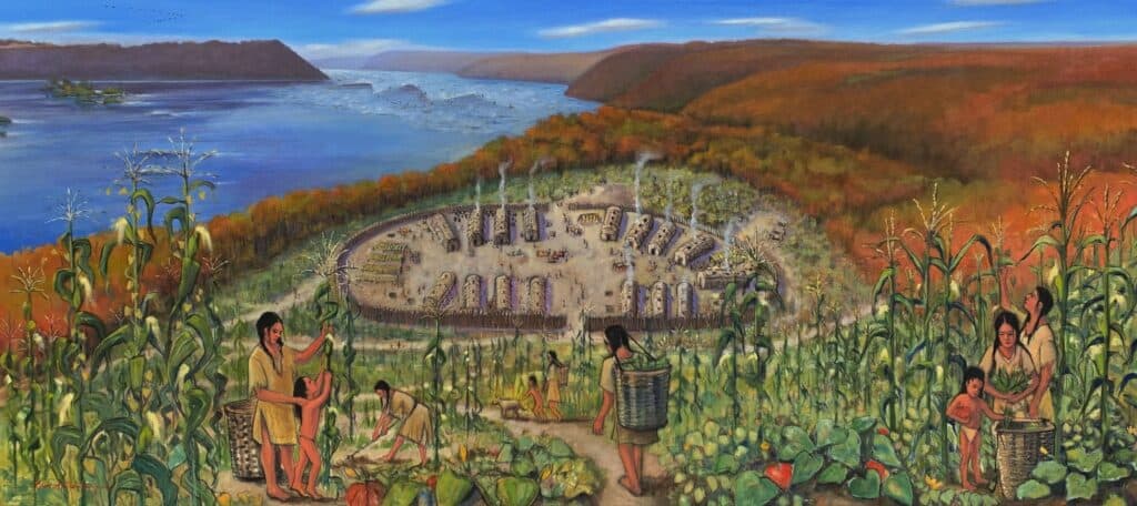
“Native Lands” Painting by Carol Oldenburg
Black Moshannon State Park
(West Branch) Situated along Moshannon Creek, Black Moshannon State Park was initially inhabited by Susquehannock people. The name Moshannon is derived from the Algonquian word “Mos’hanna’unk,” meaning “elk river place,” with “black” referring to the darkness of the water due to the plant tannins from the bog. Located within one of the most remote sections of the Susquehanna Greenway and the PA Wilds, it is also one of the few places you might see wild elk today.
Catawissa
(North Branch) Catawissa, a borough in Columbia County that sits upon the banks of the Susquehanna, derives its name from the Indigenous word “Catawese.” Authorities differ as to the nationality of the aboriginal tribe which made their home in the area. Redmond Conyngham, a prominent settler in the area at the time (and after whom Conyngham Township is named) stated that “The Piscatawese, or Gangawese, or Conoys had a wigwam…at Catawese, now Catawissa.” Stewart Pearce, another renowned area historian of that time, asserts that the Shawanese tribe established a village at Catawissa in 1697, or about that time. Regardless, the word “Catawese” occurs in several different indigenous dialects, including the Shawanese and Delawares, and always with the same meaning: “pure water.”
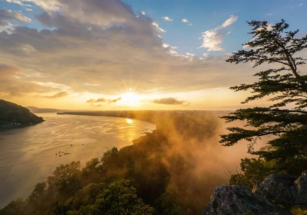
Chickies Rock
(Lower Susquehanna) Chickies Rock, a stunning 400-foot overlook situated where Chiques Creek runs into the Lower Susquehanna, is a derivation of the Algonquian word “Chiquesalunga” meaning “place of the crayfish.” Many Indigenous names are written multiple ways, like “Chickies” and “Chiques;” since these words were not originally written using the English alphabet, accepted spelling often varies.
Photo by Adam Hoke
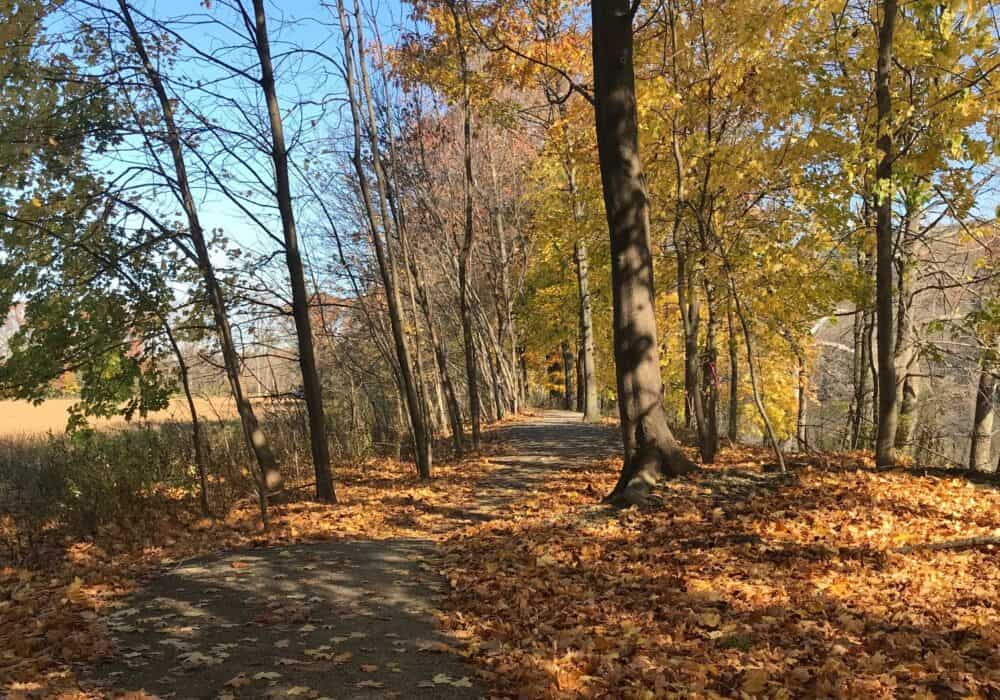
Conestoga Trail
(Lower Susquehanna) Conestoga, a name commonly found throughout south central PA, was the English name for the Susquehannock. The term is often used to refer to the smaller groups of Susquehannock that remained as their numbers dramatically decreased. The Conestoga Trail offers several scenic overlooks of the Susquehanna River along its 14.3-mile stretch.
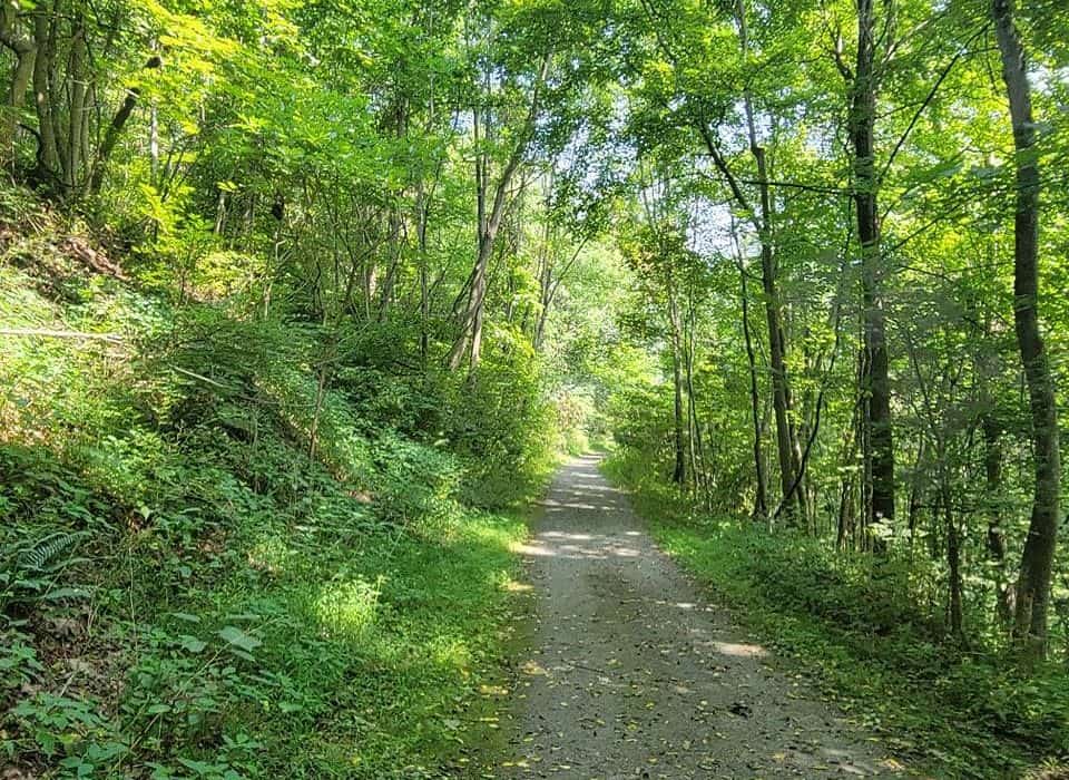
Diahoga Trail
(North Branch) The Diahoga Trail, which saw its grand opening in 2019, runs 1.5 miles from Athens to Sayre. The word “Diahoga” comes from the Susquehannock name for what is now the town of Athens. The name, which means “at the forks,” is fitting for the community, which is situated at the confluence of the Chemung River and the North Branch of the Susquehanna River.
Iroquois Trail
(North Branch) This 3-mile trail is located near the town of Tunkhannock, another town with rich Indigenous history. Although the name Iroquois is still widely used today, it is actually a derogatory term that the French used to refer to the Haudenosaunee people. The term is a mispronunciation of the Algonquian word for “snakes”—an insult used originally by the Algonquians, who engaged in continued conflict with the Haudenosaunee.
Loyalsock Township Riverfront Park
(West Branch) Loyalsock comes from the word “Lawi-Saquick,” meaning “middle creek,” in Algonquian. The Loyalsock Township Riverfront Park is located on the site of a former Native American village called Ostonwakin, meaning “a rock,” which expanded into what is now Montoursville.

Mocanaqua Trail
(North Branch) A popular trail in the coal country region of the Susquehanna, Mocanaqua’s name derivation is a reminder of Frances Slocum, who was kidnapped by three Delaware warriors in an attack on the Slocum family farm in nearby Wilkes Barre. Not only is this story the origin of Frances Slocum State Park, but it also has ties to the name “Mocanaqua.” Little Frances, who was only five years old at the time of her abduction, was brought westward and eventually traded for animal pelts to a childless couple in the Miami tribe who named her “Maconaquah,” or Young Bear. As Maconaquah grew older, she became a celebrity of sorts within the native community. She was known not only for her light skin and flaming red hair, but also for excelling at the foot races and games on horseback often played by young braves. Ultimately, she married a Miami tribe leader in Indiana and lived there until her death in 1847 at the age of 74.
Photo by Debbie Perkins
Nescopeck
(North Branch) The borough of Nescopeck, just across the Susquehanna River from Berwick, derives its name from a creek of the same name that flows south from the river on the edge of town. “Nescopeck” comes from a Lenni Lenape (Delaware tribe) word meaning “deep black water.” The current community of Nescopeck occupies the original site of the Delaware tribe’s village.
Shickshinny – A Susquehanna Greenway River Town
(North Branch) Conflicting interpretations state that Shickshinny means either “a fine stream” or “five mountains.” Either name would suit this SGP River Town, which is situated along a small creek and ringed by five mountains.
Shikellamy State Park
(Confluence) One of the most recognized Indigenous names in the Susquehanna River Valley is that of Chief Shikellamy, the namesake for Shikellamy State Park, which is situated at the confluence of the North and West Branches of the Susquehanna River. Shikellamy was a leader of the Haudenosaunee Confederacy who lived in modern-day Sunbury in the mid-18th Century and served as an emissary from the Haudenosaunee in New York to the colonial government in Philadelphia.
Photo by Charisse Baldoria
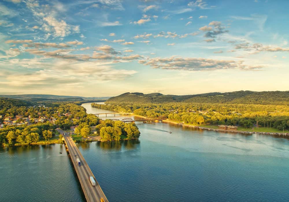
Susquehanna River
The Susquehanna River is named for the Susquehannock people who inhabited the Susquehanna River Valley and surrounding areas at the time of European contact. Variations on the suffix “hannock” are commonly found throughout the Susquehanna Greenway—its meaning in the Algonquian language is “moving water” or “river.” Sources conflict on the full meaning of Susquehanna, with interpretations ranging from “oyster river” to “muddy river.”
Tiadaghton State Forest
(West Branch) Tiadaghton is the name the Haudenosaunee gave to Pine Creek, a major tributary that runs into the West Branch of the Susquehanna. The Pine Creek Path, which passes through Tiadaghton State Forest, connected Native villages along the Susquehanna River with other Haudenosaunee communities in New York. A rail line was later constructed along its route, which has since evolved into the popular Pine Creek Rail Trail.

Towanda River Walk
(North Branch) Towanda means “burial ground” in the Algonquian language and, indeed, the town of Towanda is located near a Nanticoke burial site. The Nanticoke’s traditional homelands lie around the Chesapeake Bay; however, in the 18th Century, some members of the Nanticoke people moved North into Pennsylvania, seeking the protection of the powerful Haudenosaunee.
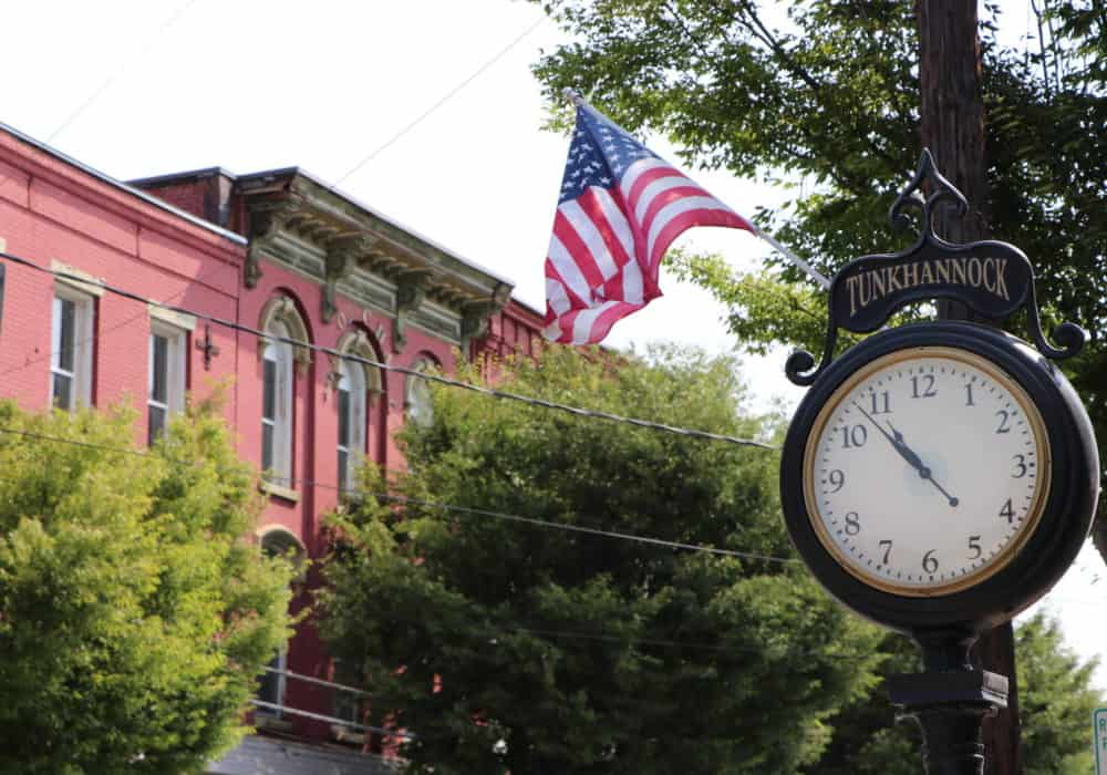
Tunkhannock – A Susquehanna Greenway River Town
(North Branch) The name of the SGP River Town of Tunkhannock has various interpretations; some maintain that it signifies “small stream,” while others have traced it to mean “a bend in the river,” referring to a sharp upriver bend known as “the Neck” or “The Vosburg Neck,” which is now a state park.
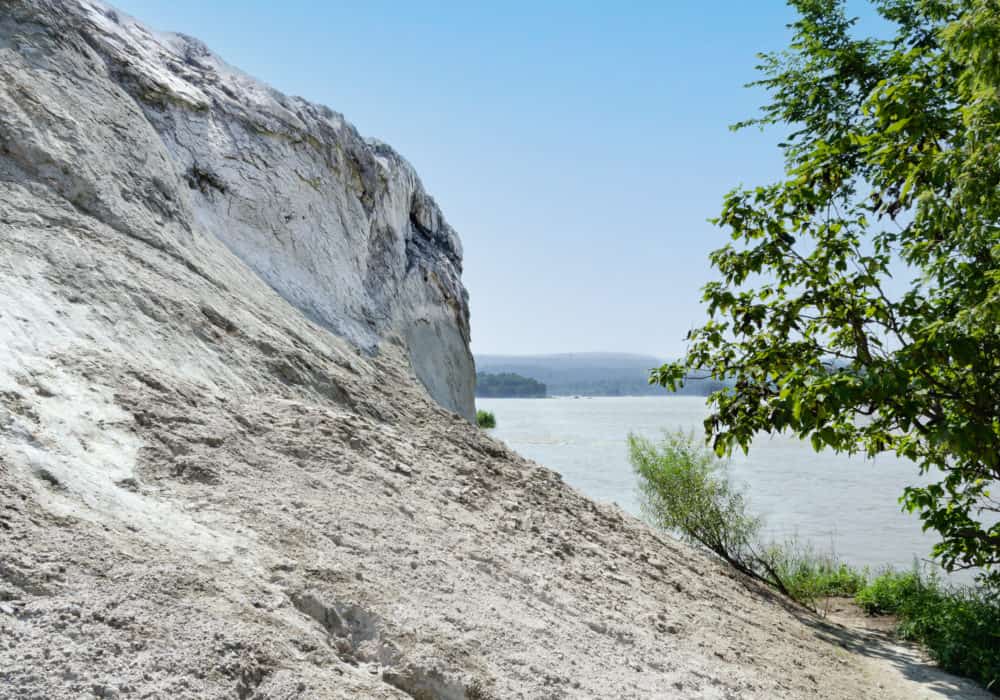
White Cliffs of Conoy
(Lower Susquehanna) The White Cliffs of Conoy, located in south central PA, are named for the Piscataway Conoy Tribe, a group of Nanticoke people who traditionally lived along the Potomac River. They moved North with other Nanticoke people in the early 1700s, seeking land and protection. These cliffs are actually a limestone deposit which can be explored just off of the 14.2-mile Northwest Lancaster County River Trail.
Photo by Mark Kissinger
Indigenous voices are essential to understanding our relationship with the land. When visiting one of these spots along the Susquehanna Greenway, take some time to consider its importance to the Haudenosaunee, Susquehannock, Nanticoke, and others who previously called it home. While the Susquehannock people are no longer active in the area, the Haudenosaunee Confederacy is an important force in the Northeast today. For more information, visit their website at haudenosauneeconfederacy.com.
The Susquehanna Greenway is a corridor of connected trails, parks, river access points, and communities, linking people to the natural and cultural treasures of the Susquehanna River. The mission of the Susquehanna Greenway Partnership is to continue to grow the Greenway by building connections along the Susquehanna River, inspiring people to engage with the outdoors, and transforming communities into places where people want to live, work, and explore.